

By Breanna Carnduff
Counter-Memorial for the
Waterton Lakes National
Park Boundary Marker
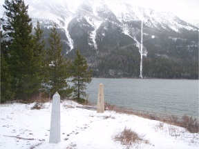
In his book, The Texture of Memory, James E. Young discusses a kind of monument in Germany that is known as “stumbling stones.” The monuments are integrated into the landscape so that people notice them by literally stumbling over them. This is the model I have used in writing a counter-memorial for the frontier marker in Waterton Lakes (Alberta) and Glacier International Peace Park (Montana) that separates the border between Canada and the United States. I chose this model because the landscape has become an important part of the monument, and vice versa. My counter-memorial, if placed next to the current border markers, would keep with the theme of stumbling stones. The counter-memorial would consist of three stones in the centre of the two existing obelisks, each bearing a plaque discussing different perspectives on the creation of the Canada–United States border, and early borderlands history.
The goal of these plaques would be to provide depth and perspective to the conversation begun by the existing markers. The conversation would be enriched by supplementing the information on these international markers--markers which function as symbols of past politics, geopolitical divisions, and local history. That said, it would be impossible to include every possible perspective in such an undertaking. I am limited by my own perspective and by research. I have chosen to highlight some of the absences that characterize the current memorial--those that I feel were most relevant to the initial creation of the 49th parallel.
Stone 1 plaque text
The border survey expedition (1872-1874) resulted in the placement of a boundary marker on the Great Divide, west of Upper Waterton Lake. The commission was made up of surveyors from Canada, Great Britain, and the United States. It took two years to complete and covered over 3 000 kilometres of territory between Manitoba and Alberta. The task of the surveyors was to accurately survey and mark the 49th parallel, resulting in the bisecting of the continent of North America.
Stone 2 plaque text
The aboriginal population that lived and hunted in the Alberta–Montana plains and mountains had survived off this land for thousands of years. Their lifestyle consisted of constant travel across what settlers deemed the 49th parallel, following the herds of bison that provided food and other life necessities. This travel defined their culture and existence. The marking of the border by the Canadian and American governments cut right through this traditional territory and, coupled with the reserve system put in place by various treaties, led to the decline of the this culture and the rise of the settler society in Western North America.
Stone 3 plaque text
Women, just as much as men, played a large role in the shaping of the borderlands on both sides of the 49th parallel. Women of all races and social classes had a stake in the culture and creation of the Alberta–Montana border. While creation of the border marked a distinct end to the mobility and cultural independence of native women, settler women were able to live and work more freely in the lands just north and south of the 49th parallel. The border, and migration across it, was less regulated in the late nineteenth century, and women (along with their families) frequently crossed this imaginary frontier. Many had family on both sides of the line. Women also played a role in the economic development of the area, both north and south, holding jobs, participating in unions, and eventually running for and holding political office.